
By: Dr. Pranab Kr. Das, Assistant Professor, Dept. of Geography, Sree Chaitanya College, Habra

Courtesy: kolkata24x7
Introduction:
Flood is not an unknown incident in Deltaic West Bengal. The southern part of it generally does not face this problem as it is close to the Bay of Bengal. The tidal channels drain out excess run-off to the sea. However, the northern part has no such facilities. This part of the delta faces local (small to moderate scale) flood due to poor drainage system. In recent times, there is no such record of big flood after 2000. In 2000, the majority part of Moribund and Mature delta experienced a devastating flood. The Active Delta somehow survived due to tidal effects as mentioned earlier. There is no doubt that the flood incident of the northern and central part of Deltaic West Bengal is very much associated with the flood of western tributaries of Bhagirathi Hooghly mostly Damodar Valley. So, before discussing the flood of Deltaic West Bengal, we have to analysis the flood of Damodar Valley.
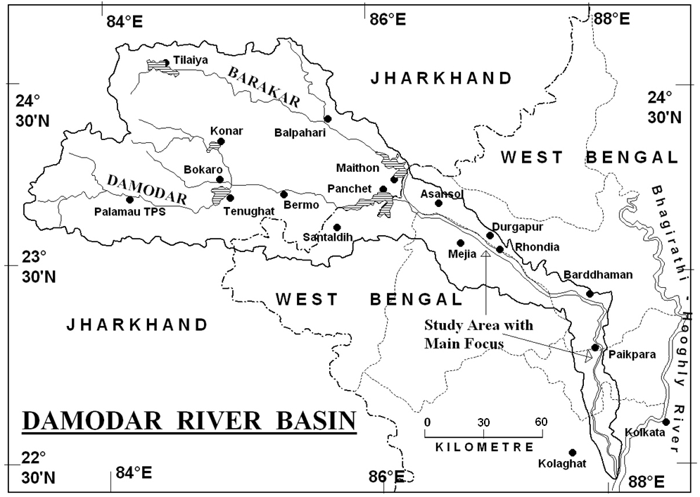
The Damodar Valley is one of the most flood prone areas in West Bengal. The total area of Damodar valley is 24235 sq km. Its source is the Khamarpat Hill of the Chhotanagpur Plateau. The upper Damodar basin is located in Jharkhand and the lower basin is in West Bengal. The river flows mainly through Hazaribagh, Ramgarh, Koderma, Giridih, Bokaro, Chhatra and Dhanbad districts of Jharkhand and Burdwan, Bankura, Hughli and Howrah districts of West Bengal and joins the Hooghly River at Garhchumbak near Uluberia. The main tributaries of Damodar are Barakar, Konar, Jamuria, Bokaro, Ghari, Khadiya etc. The upper Damodar basin is mainly plateau rich in mineral resources but the lower basin is the agrarian plains.
History Floods in Damodar Valley:
Almost every year, the Damodar Valley and adjacent sites face minor floods, and in a few years interval devastating floods occur. The pre-independence floods were more severe and regular. The flood of 1730 was the first recorded flood in the Damodar valley. Subsequently, severe floods occurred in the lower Damodar basin in 1823, 1848, 1856, 1859, 1863, 1882, 1890, 1894, 1901, 1905, 1907, 1913,1916,1923,1935 and 1943. This is why the Damodar River was called the ‘Sorrow of Bengal.
D. V. C Project:
After the catastrophic floods of 1943, the then British government formed a high-level committee to determine the cause of the floods in the region and ways to control it. One of its members was the Maharaja of Burdwan and eminent physicist Dr. Meghnath Saha. Following the recommendations of the committee, W.L Voorduin, one of the leading settlers of the Teensy Valley Corporation authority in the United States, was requested to give a report to resolve the flood problem in the Damodar Valley.
In 1944, W.L. Voorduin submitted his detailed report. His recommendations for the overall development of the Damodar Valley (2,220 sq km) are:
- Construction of 7 major dams in upper basin for flood control,
- The construction of barrages or barrages in the lower basins to divert Damodar water to agricultural lands through irrigation canals,
- Rapid industrialization and urbanization through hydropower and thermal power generation.
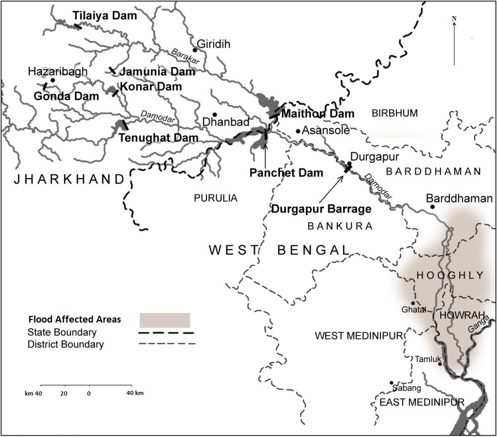
The DVC officially debuted on July 7, 1948 according to the Constituent Assembly Act of India, which is known as Damodar Valley Corporation Act (Act No. XIV of 1948). It was a tri-partite agreement with partners Bihar, West Bengal and the Indian government. The initiative was the first in the subcontinent as a multipurpose river plan. The seven main reservoirs that Varduin proposed were Tilaiya and Mython on the Barakar River; Aiyar, Panchet and Barmo on Damodar; Bokaro on Bokaro and Kona Dam on the Kona River. If his plan went into effect, there would be about ten million cusecs of water control during the final flood. Moreover, as part of the plan, the entire project had the opportunity to generate 1 lakh to 1.5 lakh kilowatts of electricity from hydropower and thermal power plants combined. But in reality only four main dams were constructed at Tilaiya, Panchet, Maithon and Konar and at Durgapur a barrage of 692 m length and 12 m height was constructed on the lower Damodar. The length of the irrigation canals on the right bank of this barrage is 88 km and the left bank canals 136 km in length. The construction of these dams has benefited 8 lakh hectares of agricultural land during Kharif season and 22 thousand hectares of agricultural land during the Rabi season. Later, relatively small dams on Damodar have been built on Tenughat, Gonda and Barakar.
Current status of DVC’s Main Dams:
The average age of the dams in Damodar Valley Corporation is about 60 years. Due to excessive mineral extraction, deforestation and rapid urbanization in the upper basin, soil erosion has reduced the water holding capacity of the four main dams by 26.95% (Table 1). Open pit mines in the upper Damodar Basin are rapidly depleting the capacity of dams due to soil erosion. The overall situation of Damodar and its tributaries are quite alarming. Due to the construction of dams in the upper basin, the normal flow of rivers in low basin is affected badly. Due to the lack of discharge from the dams in the dry season, the natural flow is weak and the river channel is decayed in lower channel. Currently the riverbeds are wide but very shallow. In addition, the carrying capacity of the rivers has been alarmingly reduced due to the accumulation of airborne waste or debris from the surrounding areas. As a result, the Damodar and its branches can’t carry the excess water in Monsoon. When the Damodar and other rivers flow eastwards with this excess water, bridges, culverts, railways and roads built across the rivers create obstruction to them. The drains under these railways and highways are so small that they almost dilapidated due to lack of maintenance. So, it is not possible to drain the water through them, resulting in long standing flood water. At present, the situation is so worst that when the flood water (released from dams) comes suddenly, there is no room for it. It neither goes to sea smoothly nor even fall uninterruptedly to the main river. So, there is a prolonged water blockage in surrounding areas.
| Dams | Year of Establishment | Primary Capacity (000 Cubic m) | Present Capacity (000 Cubic m) | Primay Depth in m | Present Depth in m | Maximum Water Discharge (Cubic m/Sec) |
| Tilaiya | 1953 | 380710 | 305930 | 372.47 | 371.56 | 1348 |
| Maithon | 1958 | 1093540 | 803620 | 152.40 | 150.88 | 13592 |
| Panchet, | 1959 | 1193464 | 748375 | 135.64 | 132.59 | 16608 |
| Konar | 1955 | 247960 | 213560 | 427.94 | 427.06 | 6796 |
| Total | 2915674 | 2071485 |
In this context, another thing to note is that here the dams were mostly built in the upper Damodar basin where the amount of rainfall is less than in the lower basin. Generally, the cyclones formed in the Bay of Bengal cause heavy rainfall in the lower basin before reaching the upper basin (Chhotanagpur Plateau) and soon the river basins become full. After that when the cyclone persists in upper basin, the dams are forced to release water due to excessive rainfall. The lower channels, which were already full of water with cyclonic downpour, become imprinted and floods occur. In some places the floodplains of the river are lower than the river basin, so that once the flood water enters, it cannot be easily drained. At this time, if there is a full Kotal (strong flood tide), then the lower basin water will take longer to get into the Hooghly River and the situation becomes critical.
Role D.V.C in Flood Control- Full of Controversy:
In the political arena of West Bengal, since the Great Flood of 2000, it has been widely rumored that floods in the western districts are not normal, ‘man-made’. The same thing is being repeated various years. The recent year’s data from DVC is not available; we will discuss the data for 2015. In 2015, Cyclone Komen in West Bengal caused heavy rains and severe floods and affected about 1.06 crore people in 222 blocks of 13 districts of South Bengal. On July 15, ‘Komen’ hit the coast of West Bengal. When it down felled on the West Bengal coast, transformed into an extreme low pressure and caused heavy rains in the entire South Bengal for more than a week. In the final stages, ‘Komen’ became active over Jharkhand, resulting in heavy rainfall in the Upper Damodar Basin and increasing pressure on the dams. As a result, DVC was forced to release water in early August, mainly from Tilaiya and Maithan dams. These two dams are located on the border of Jharkhand and Bengal, so the release of water from them is bound to affect the western districts. A total of 95,000 cusecs of water was released from the two dams on 3rd August. According to the DVC authorities, the reason for excluding this water is that the capacity of the lower basin is 11000 cusecs. But by the time the water recedes (August 1-4), the lower basin had already been flooded due to earlier heavy rainfall. In addition the downward flow of water was slow due to high tides. In this case, it is debatable how D.V.C released 86% water of the downstream capacity?
At 12 noon on August 5, the water level in Maithan was 148.68 meters and in Panchte 128.28 meters, which is slightly lower than the safe limits of 150.88 meters and 132.59 meters, respectively. So could this disaster have been prevented? According to critics, one of the reasons for the release of water is power generation. Because Maithan and Panchte are the main sources of DVC hydro power generation. From July 1 to August 8, the two centers produce electricity from 1.81 million units to 2.64 million units, a 46% increase! During these four days, the water level remains unchanged at the same rate, which is about 40% higher than normal, while the lower basin was already flooded at that time.
Role of irrigational Department of West Bengal:
On the other hand, according to the DVC authorities, water has been released from the reservoirs with the permission of the Damodar Valley Reservoir Regulation Committee, Central Water Commission. One of the members of the Damodar Valley Reservoir Regulation Committee is the Chief Engineer of the Irrigation Department of the Government of West Bengal. Thus, there are questions about the state government blaming the DVC authorities for not informing in advance about the release of water immediately after the floods. In fact, the West Bengal government’s irrigation department has an important role in deciding whether to release water from the reservoirs. If West Bengal Govt. denied it then there might be lack coordination with its own irrigation bureaucrats. So the claim from the state government, the main cause of the floods in Burdwan, Howrah and Hooghly is released water from DVC is true. However, the state government cannot deny its responsibility. The Burdwan district of West Bengal has been benefited the most from the DVC project and transformed into a ‘Grain Shade of Bengal’. The role of irrigation canals in the cultivation of Rabi cultivation in Hooghly, Howrah district is huge. The irrigation canals have a great role to play in flood situations. But the canals are not well maintained. It is the responsibility of the Irrigation Department of the State to improve the lower channel of Damodar (silt removal, dam repairs etc.) and associated canals. In addition, the state administration will have to resist the way in which the sand mafias are unwittingly stealing sand from the riverbed and disrupting the normal course of the river.
Coordination for Better Flood Management:
After the flood, the responsibility of the government should not be limited to the distribution of relief materials. There must be long term planning. In this case, first of all, the coordination between the Government of West Bengal and Jharkhand, the Regional Meteorological Department, the DVC Authority and the Central Water Commission is very important. DVC authorities should publish the actual information about the water discharge on a regular basis in their websites and to eliminate the confusion. D.V.C can construct check dams in the container basin through Micro Water Shade Management, where the height and volume of the dams will gradually increase below the slope of the terrain. By which the downstream flow of the water can be further delayed during flood and more time will be available for Government to run rescue work. The state government should regularly inspect and maintained river embankments in the lower Damodar basin through its irrigation department. Strict action should be taken immediately against the sand mafia so that the rivers can flow according to their normal course.
Finally, it is important to mention that, in the present context, no flood can be called natural. It is true that the main cause of the flood is excessive rainfall and exceeds of water holding capacity of the rivers, which can only be termed hazard. Whether this hazard will turn into disaster, it depends entirely on human activity. This means, heavy rains create the risk of flooding but human activity increases its severity and intensity. Nowadays, floods are called Quasi Natural or semi-natural disasters. So any flood is neither entirely natural nor so-called ‘Man-Made’.
Effects of Damodar Valley’s Flood on Deltaic West Bengal:
If there is any flood in Damodar or adjacent rivers, the flood water comes to Bhagirathi-Hooghly channel. The level of water in Bhagirathi-Hooghly increases and the excess enters into the eastern distributaries through Jalangi and Churni. The Jalagi-Churni-Mathabhanga-Ichhamati river system is very complex and decayed. The channels are narrow, shallow, often disconnected from their sources. In various areas, the channels disappeared in shallow marches (cut-offs), so they can’t hold excess water from Bhagirathi-Hooghly. Due to the lack of natural flow, the depth of these channels is very low. So, during the flood, the shallow rivers immediately are overflowed and water moves towards the flood plains. With the presence of wetlands and marshes, the local topography has become bowl-shaped. So, flood water store for a long time and can’t be carried by the rivers. In, 2000 the large areas of Nadia, North 24 Parganas faced this scenario.

Hi Dr Das this is M N Ray a retired Chief Engineer from Nuclear Power Corporation Dept of Atomic Energy.Though I was initially for4 years with Central Water Commission,but later on Joined MES as Ind Defence Service of Engineers(Class-1) .Later I joined Dept of Atomic Energy for Nuclear Power Project planning&Civil design IN Mumbai. While panning and doing preproject engineering for Nuclear Project ,Flood estimation and probabilistic flooding our site by any river passing close to our plant site was always been done through CWPRS Pune under my association. So please tell me If DVC is not desilting its reservoir(which Chinese are doing very efficiantly) desilting downstream channels will serve a majour relief to Bengal?
LikeLike